When we think of a map, we think of it as an almost immutable source of facts.
However, not only are maps often grossly inaccurate in terms of the relative size of different regions, but geographical boundaries are often disputed than they might seem to those who have received education in North America, a region which has not had a major change of boundaries between sovereign states since 1949 – long before most of us were born. Looking at national border changes since World War I, it is clear that this hasn’t been the worldwide norm. The changes within Europe, Africa, and Asia have not only been more numerous than those in this part of the world, but also more significant.
While those of us whose knowledge is largely based in a North American context may think of these changes (due to their presentation as historical fact, rather than an ongoing dispute) as cut-and-dried, they often aren’t: many boundaries are still being contested. The way that these boundaries are depicted, both verbally through education and the media, and visually through maps and globes, shows the relations between the countries involved in the dispute, as well as how global communities view the disputed area. One of the most visible ways this manifests is in Google Map depiction of disputed boundaries.
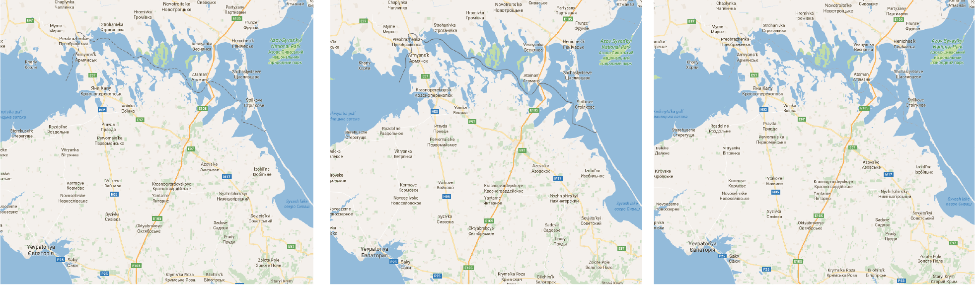
On Google Maps, disputed boundaries are shown by dashed lines, rather than by the solid lines which are usually used to indicate the borders between two countries. This came to mainstream attention earlier this summer, when Google was accused of deleting the label for Palestine on its Maps (Google later stated that there had never been a Palestine label, but a bug had caused the labels for the West Bank and Gaza to disappear, which was rectified later). The boundaries between the West Bank and Israel, and between Gaza and Israel, are displayed by dashed lines. These dashed lines recognize that the boundaries between these territories are not nationally or internationally agreed upon.
This is not the only way in which Google attempts to remain impartial on the issue of what it calls “sensitive borders.” When you search for a country which has had historically well-defined, undisputed borders, Google highlights the border in red, and overlays a translucent red highlight over its territory. In the summer of 2014, however, Google treated 32 countries differently: when searched, they were either simply zoomed-in on, or the red Google pin was placed somewhere within their territory. Now, eight of those countries (Albania, Georgia, Mauritania, Mauritius, Montenegro,Nauru, South Sudan, Macedonia) have their borders highlighted in red when searched, reflecting past geopolitical changes that Google has decided to formally recognize.
However, even these layers of complication are not a complete picture of Google’s attempts to avoid conflict. There are several territories which have different boundaries depending on which country code top level domain (ccTLD) – .ru, .ca, etc. – is used to access Google Maps. A 2014 hackday (a day where coders interested in forms of “hacking” get together and collaborate on projects) sponsored by the Knight Foundation, Mozilla, and the Massachusetts Institute of Technology, and dedicated to the idea of “the Open Internet,” or internet neutrality, resulted in a list of “notable examples” of disputed territories which have different appearance on Google Maps depending on the viewer’s location.
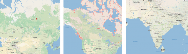
The site shows the results of searches for these disputed territories from the U.S. view, as well as the “administering” country and the “claimant” country. These territories are: Aksai Chin, Arunchal Prades, Azad Kasmir and Gilgit-Baltstan, Bhutan (Chumbi salient and northwest valleys), Crimea, Demchok, Jammu and Kashmir, Pinnacle Islands, Shaksam Valley, Siachen Glacier, Spratly Islands, and Tirpani and Bara Hotii valleys. While this is not a comprehensive list, it does offer a look at the extent to which Google must consider the ramifications of its decisions; there are many countries implicated, and millions of people implicated.
The reasons for Google’s decisions are manifold. Google must follow the laws of the countries the accessing servers reside in, and relies on this rather than the judgments of a supranational power, such as the United Nations (U.N.), due to the U.N.’s lack of topographical tools: the U.N. Regional Cartographic Conferences meet only every three years, far too infrequently to be reliable for the settlement of disputes, and their maps are often not as detailed as Google’s. Google moves quickly – in the case of Crimea, it only took two weeks after the Russian vote to annex before Google Maps was updated – but it also maintains an expectation of quality mapping. This is why, when South Sudan was added as an independent country, it took two months for the boundaries to appear on the map; the U.N. decision did not make clear delineations, and the government’s delineations were not those commonly used. In order to rectify this, Google organized a series of events in Nairobi dedicated to community mapping South Sudan. In order to maintain the standard that Google is accustomed to, while also complying to local laws, Google has had to resort to what is known as “agnostic mapping” – acknowledging that there is no one objective reality, even when it comes to global boundaries, and providing cartographic information in compliance with this principle.
Google Maps decisions aren’t arbitrary, nor are they inconsequential: in 2010, a mistake in Google Maps almost launched a war between Costa Rica and Nicaragua when Nicaraguan officials believed that Google-drawn boundaries, later shown to be a mistake, indicated a Costa Rican invasion of already contested land. More recently, India drafted a law (which was not passed into legislation) which would allow for fines levied on those who publish inaccurate cartographic information to reach up to 1 billion rupees, or about 20 million Canadian dollars. Google’s transparency in regards to disputed boundaries is admirable – most of the time, to see a different country’s view, all you need to do is to change the ccTLD.
However, the lack of a consistent approach to these boundaries, or an official, regularly updated list limits the knowledge of viewers. Whether these viewers are players in world politics with the ability to launch troops, or students who are learning about geopolitical boundaries and only have certain viewpoints readily available to them, Google Maps has a responsibility to be as transparent as possible with its location and treatment of boundaries.